Xiongan New Area | Dimension-Upgrading Construction from BIM to TIM
WeChat Sync · Xiaowei · 2025-03-12
The following article is sourced from BIM New Insights
Ministry of Natural Resources of the People's Republic of China
Building the National Territorial Spatial Planning Implementation Monitoring Network
The 20th National Congress of the Communist Party of China made the strategic deployment of accelerating the building of a cyber power and a Digital China. The Outline of the National Territorial Spatial Planning (2021-2035) and the Overall Layout Plan for Building a Digital China, issued by the CPC Central Committee and the State Council, explicitly require the construction of a national territorial spatial planning implementation monitoring network. The national natural resources work conferences of 2023, 2024 and 2025 continued to make further deployments, stressing the need to keep advancing the construction of the territorial spatial planning implementation monitoring network, to improve the policy mechanisms and technical standard system for digital governance, and to strengthen the evaluation and supervision of plan implementation. In September 2023, the General Office of the Ministry of Natural Resources issued the Work Plan for Building the National Territorial Spatial Planning Implementation Monitoring Network (2023-2027), which clarified the construction goals, working principles, main tasks and supporting measures, with a view to fully building smart territorial spatial planning that is “perceivable, learnable, well governed and self-adaptive”, vigorously promoting the “digital-intelligent” transformation of territorial spatial governance, and advancing the development of a digital governance system for a Beautiful China and of a green, smart digital ecological civilization. In December 2023, the General Office of the Ministry of Natural Resources issued the Notice on Deploying the Pilot Work for Building the Territorial Spatial Planning Implementation Monitoring Network, specifying that pilots would be carried out in the Yangtze River Delta Ecological and Green Integrated Development Demonstration Zone as well as in 16 provinces, 29 cities and 1 district/county. In order to explore a new governance mechanism of “co-construction, co-governance and sharing”, rally the strength of the whole society and advance the high-quality construction of the territorial spatial planning implementation monitoring network, the former columns on territorial spatial planning “one map” construction and the ongoing urban physical examination have been merged into the CSPON (China Spatial Planning Observation Network) construction column, which openly solicits from all sectors of society the theoretical methods, international experience, frontier trends, technical roadmaps, algorithm models and practical experience for the two sections of “smart territorial spatial planning” and “monitoring, evaluation and early warning of territorial spatial planning”. Key laboratories, engineering technology innovation centers, sci-tech innovation talents and teams, institutions of higher education, research institutions, industry practitioners and enterprises, as well as natural resources departments and units at all levels in the relevant fields, are welcome to submit contributions; there is no restriction as to whether the contributor is an organization or an individual. We will take the quality of the results as the sole criterion and select the best for publication (submission email: ghjdcyzt@163.com). Under the guidance of the Bureau of Territorial Spatial Planning of the Ministry of Natural Resources, Tongji University (Key Laboratory of Territorial Spatial Intelligent Planning Technology, Ministry of Natural Resources) and the Territorial Spatial Planning Research Center of the Ministry of Natural Resources, together with Shanghai Tongji Urban Planning and Design Institute Co., Ltd., the College of Architecture and Urban Planning of Tongji University, China Natural Resources News, Urban Planning Forum and Urban and Rural Planning, held the UP Frontier Forum in Shanghai on the theme “From CIM to TIM - Building New Infrastructure for a Digital Ecology”. We will publish the themed reports in succession. This issue presents Xiongan New Area: Exploring the Dimensional Upgrade Path from BIM to TIM.
— Bureau of Territorial Spatial Planning, Ministry of Natural Resources
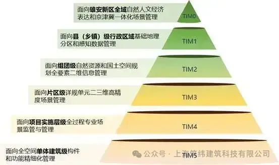
The development of the Territory Information Model (TIM) for Xiongan New Area is built on the new generation of information technology. Drawing on the practical experience of Building Information Modeling (BIM) and City Information Modeling (CIM) in Xiongan New Area and oriented toward the business scenarios of territorial spatial use control, it proposes a TIM research approach of “urban-rural coordination, full-element coverage, from surface to interior, spatiotemporal three-dimensionality and dynamic updating”. The research puts forward a theory for building thematic databases with six levels from TIM0 to TIM5 and the integration of 2D and 3D data, forming a “dynamic model” that covers the entire territory, all elements and both above-ground and underground space, and building a data knowledge graph. Adopting the path of “scenario-driven - standardized processing - fusion governance - scenario application”, it supports the scenarios of physical examination and evaluation of plan implementation, relief of projects under Beijing's non-capital functions, and full-process monitoring of spatial use, thereby empowering full-lifecycle digital governance of territorial spatial use control business.
The Essential Needs for Building TIM
The essence of building TIM is to reconstruct the digital twin system for territorial spatial governance and to provide a data governance framework for the survey and monitoring of the territorial spatial baseline and its changes. TIM is perceivable and computable. Applying TIM can directly support all business management activities of natural resources administration, making TIM-based digital management itself a source of monitoring data, and thus forming a computable data ontology that solves the problem of the lack of dedicated surveys in monitoring the implementation of territorial spatial planning. TIM is good at governance and capable of learning. With big data analytics, statistical analysis of spatial changes can be achieved and the effectiveness of plans and policies can be evaluated, providing space-based evidence for territorial spatial governance. Through time-series data analysis and the comparison of macro- and micro-level data, it can identify conflicts between people and land, simulate and predict the evolution of the people-land relationship, and automatically detect problems and assist in solving them.
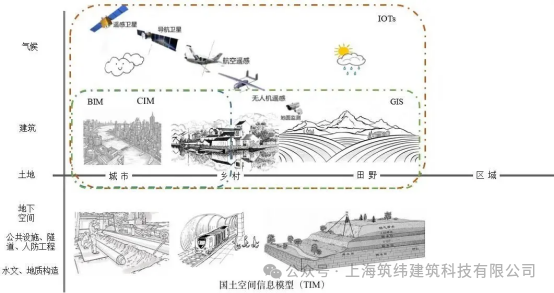
The Dimensional Upgrade from BIM to TIM in Xiongan New Area
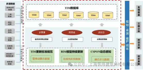
Upgrading BIM to TIM in Xiongan New Area. In building the TIM system, Xiongan New Area draws on the experience of BIM development, guided by the business needs of plan implementation and by data refinement, so as to achieve dynamic data updating and the interconnection of data at higher and lower levels.
The construction technologies of TIM in Xiongan New Area. It proposes a thematic database theory with six levels from TIM0 to TIM5 and the integration of 2D and 3D data, and completes work such as the sensing and acquisition of spatial data, full-lifecycle data management and the spatial positioning of unstructured data, providing a data foundation for building the territorial spatial planning implementation monitoring network (CSPON) in Xiongan New Area.
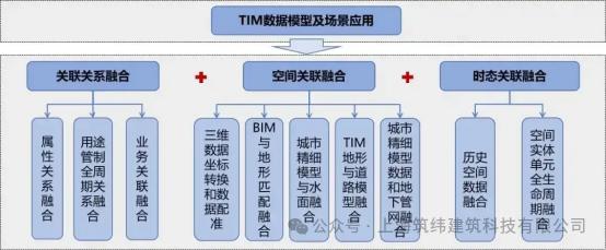
The fusion technologies of TIM in Xiongan New Area. Xiongan New Area has an abundant variety of data types and numerous data formats. Through technologies such as spatial correlation fusion, relational fusion and temporal correlation fusion, data from different business areas are brought together and data lightweighting is achieved.
The updating technologies of TIM in Xiongan New Area. Based on the existing BIM0-BIM5 model system of Xiongan New Area, and addressing the thematic data formed by existing stock data and by the incremental data from sensing and monitoring, it follows the principles of dynamic updating and periodic updating to effectively ensure data services for monitoring the implementation of territorial spatial planning.
Envisioned TIM Application Scenarios in Xiongan New Area
Adopting the research approach of “scenario-driven - standardized processing - fusion governance - scenario application”, it meets the need of territorial spatial planning implementation monitoring for “living, changing” management data at the “minimum cost of survey and monitoring”, achieves “synchronization” between monitoring work and business operation data, and makes it possible to put the monitoring of territorial spatial planning implementation into practice.
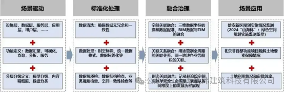
The TIM-based scenario for guaranteeing production factors in the relief of Beijing's non-capital functions. Under the TIM framework, natural resources management data and territorial spatial governance data are fused and governed so as to monitor and analyze the implementation of projects relocated under the relief of Beijing's non-capital functions and to reflect in real time the land factor guarantees for these projects. The TIM-based scenario for monitoring land use and approval efficiency. By fusing monitoring data from various information platforms and intelligently sensing changes in land use, it achieves dynamic monitoring and evaluation of land use in Xiongan New Area, produces quantitative evaluation reports based on “spatial evidence”, and puts forward recommendations for optimizing land use policies.
As the next step, Xiongan New Area will continue to follow the work deployment of the Ministry of Natural Resources and deepen research on the dimensional upgrade from BIM to TIM. Guided by business needs and supported by intelligent tools and algorithm models, it will offer a Xiongan solution for the construction of CSPON.
(Authors: Cheng Xiaojun, Director of the Comprehensive Systems Division, Department of Territorial Spatial Use Control, Ministry of Natural Resources; Huang Rui, Deputy Dean, and Ren Weiyang, Senior Designer, Xiongan Urban Planning and Design Institute Co., Ltd.; Du Xiaomin, Deputy Director of the Use Control Research Office, China Aero Geophysical Survey and Remote Sensing Center for Natural Resources; Sun Xiaobo, Engineer, Hebei Geographic Information Group Co., Ltd.)
END
The views expressed are the author's own Copyright © Zhuwei Architectural Technology
Reproduction without authorization is prohibited
Please credit the source when reposting: Zhuwei Architectural Technology
Zhuwei Architectural Technology is a new-type technical services company specializing in integrated design optimization, BIM consulting and prefabricated construction design consulting. Our team brings together senior engineers from leading design institutes, former executives of real-estate companies, BIM engineers and prefabrication engineers, delivering integrated design optimization, refined drawing review, BIM consulting with MEP detailing, and prefabricated design services.
Design optimization consulting: Positioned as an extension and complement to the design management of real-estate developers, we focus on consulting and optimization for civil buildings. Across the whole process — or at key stages required by the client — we control the economy, rationality and safety of the design, eliminating unnecessary cost while measurably improving drawing quality, achieving "lower cost, higher efficiency".
BIM consulting: Through digital construction technology we help designers reduce errors and improve quality in the design phase, help contractors save cost and plan high-quality MEP installation in the construction phase, and extend BIM models into facility management for the operation phase — in collaboration with mainstream software vendors.
Prefabricated design consulting: Whole-process design on BIM platforms, using Revit and Tekla for PC detailing. Component geometry and reinforcement are linked parametrically — what you see is what you get. We deliver Industry 4.0-ready drawings with cut-length data for every rebar, and IoT-enabled support for production, storage, transport and installation of PC components.
Our expert team comes from leading design institutes, with deep technical grounding and extensive experience in dual-track design and optimization; its technical capability and control are industry-leading.
—— This article is auto-synced from the WeChat Official Account “Zhuwei Architectural Technology”. Read the original ——